

Published: 2026-07-29 | Author: Karl Huang
When I sat down to build this Xinjiang Hiking Guide three years ago, I had just finished a five-day walk between Hemu and Kanas in the Altay range. I paid 195 yuan for the Kanas reserve entry, another 100 yuan for the shuttle bus, and hired a Kazakh guide named Aiben for 400 yuan a day because the ridge route was still half-covered in September snow. We left the guesthouse at 7:30 in the morning while the wooden boardwalk was empty. That trip taught me more about planning hikes here than any brochure, and most of what follows comes from hikes I actually walked. I publish it as part of a wider Xinjiang travel guide collection, but the trail notes below are all first-hand.
Quick Reference
| Trail | Region / Access | Fee | Best time | Elevation |
|---|---|---|---|---|
| Hemu – Kanas ridge | Altay, north Xinjiang | 195 yuan entry + 100 yuan shuttle | Sep – Oct | 1,300 – 2,500 m |
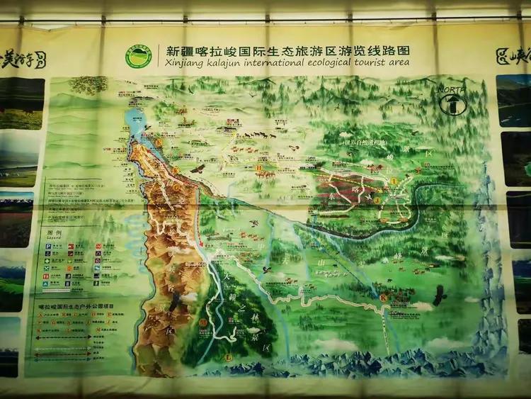
| Karajun grassland ridge | Tekes, Ili | 140 yuan | Jun – Jul | 1,600 – 2,000 m |
| Muztagh Ata base walk | Tashkurgan, Pamir | 90 yuan | Jun – Sep | 3,600 – 4,500 m |
| Tianchi lakeside loop | Urumqi, Tianshan | 215 yuan | May – Oct | 1,900 – 2,500 m |
The first time I hiked the Hemu-to-Kanas ridge, I expected a tough mountain crossing. It was not that at all. The path runs mostly along a raised wooden boardwalk built to protect the wetland, and for the first hour I shared it only with a few cows and a herder on a motorbike. Around 9 a.m. the fog lifted and the birch forest on the far shore turned gold. I stopped at a small canteen near the halfway mark and drank milk tea for 10 yuan while Aiben negotiated a ride for our packs with a local family. This Xinjiang Hiking Guide leans on that first ridge walk more than any other, because it shows how gentle and how conditional these trails can be. The lesson stuck with me: in Xinjiang, the famous hikes are rarely remote, but the weather and permits decide whether they go smoothly.
If you want a longer, wilder plan, our Xinjiang Trekking Itinerary lays out multi-day routes that connect several of the trails below. I update it every season based on what readers report back.
How to Get There
From Urumqi to Altay (north trails). Most readers of this Xinjiang Hiking Guide reach Altay by air from Urumqi (around 1 hour 40 minutes, 700–900 yuan in shoulder season). From Altay airport a shared car to Hemu takes about 4 hours and costs 120–150 yuan per seat. Buses also run but stop in Burqin, adding a transfer.
From Urumqi to the Ili grasslands. Fly to Yining (1 hour 20 minutes, 500–700 yuan), then drive 2.5 hours to Tekes for Karajun. A Xinjiang Self-Driving Guide is handy here because the grassland loops are spread out and public transport is thin.
To the Pamir trails. Fly or train to Kashgar, then drive 300 km south to Tashkurgan (about 5–6 hours). The Karakul and Muztagh Ata walks start near the highway, but you need a border permit (see tips).
To Tianchi. A direct tourist bus leaves Urumqi for Tianchi in about 1.5 hours; the loop trail begins above the lake cable car.
Best Time to Visit for the Xinjiang Hiking Guide
The best time to visit Xinjiang hiking depends entirely on which range you pick, because the regions sit at very different altitudes and latitudes.
Spring (April – May). Grasslands start greening but high passes stay muddy and some forest roads are closed. Good for low-altitude Tianchi walks, weak for Altai.
Summer (June – August). The Ili grasslands hit peak color and the weather is stable. Downside: Turpan and the Tarim Basin are brutally hot, and July–August is the crowded domestic-travel peak. Pamir is open and clear.
Autumn (September – October). My favorite window. The Altai birch and larch turn gold, skies are dry, and crowds thin after the National Day week. The sweet spot for northern colors is roughly September 20 to October 10.
Winter (November – March). Snow closes most passes and boardwalks. Only experienced skiers and the Tianshan resorts stay active.
My recommendation: late September to early October for Altai, mid-June to July for the Ili grasslands, and June to September for the Pamir. For a season-by-season breakdown across the whole region, see our Best Time to Visit Xinjiang Guide.
Where to Stay
Budget. The budget tier in this Xinjiang Hiking Guide covers both cabins and yurts. Wooden hostels in Hemu run 80–120 yuan a bed in a shared cabin. Herder yurts near Karajun cost about 100–150 yuan and often include breakfast. Book early in October; Hemu fills fast during the color season.
Mid-range. Family guesthouses inside Kanas village charge 300–500 yuan for a private room with heating. In Yining, clean business hotels near the bus station start around 260 yuan.
Upper. Resort hotels beside Tianchi and the newer lodges near Karajun go for 800–1,500 yuan, with heated rooms and lake views. On the Pamir, the best option in Tashkurgan is a comfortable 4-star at roughly 600–900 yuan.
Food
You will eat simply on the trail and well in the villages. As the Xinjiang Hiking Guide food notes show, the prices below are what I paid in 2025, and they stay steady because most dishes are local.
- Laghman (hand-pulled noodles with meat and veg): 25–35 yuan a bowl.
- Kazakh baursak with milk tea: the fried dough is 8–10 yuan, tea 5–10 yuan.
- Grilled lamb skewers (kawap): 5–8 yuan each in village squares.
- Polo (lamb pilaf): 30–40 yuan.
- Naan: 4–5 yuan, easy to carry as trail food.
- Mutton soup with noodles after a cold ridge day: 28–35 yuan.
Carry cash for the small canteens. Several stalls between Hemu and Kanas took only paper money when I last walked it.
Practical Tips
One rule in this Xinjiang Hiking Guide sits above the rest: sort the permit and the altitude before you worry about anything else. The list below covers the rest.
- Get your border permit first. Trails near Tashkurgan, Khunjerab, and some Altai frontier zones need a Border Travel Permit. It is free at the Kashgar Public Security Bureau with your passport; allow half a day.
- Respect the altitude. Tianshan and Pamir trails start above 2,500 m and climb past 4,000 m. Sleep low the night before and walk slowly the first day.
- Carry more water than feels necessary. Three liters a day on exposed ridges. Streams look clean but treat or filter before drinking.
- Block the sun. UV at altitude is intense. SPF 50, a brimmed hat, and sunglasses are not optional.
- Pack for a 15–20°C swing. Mornings on the ridge can be near freezing in September while afternoons hit 20°C. Layers beat a heavy coat.
- Hire a local guide for multi-day routes. Expect 300–500 yuan a day. Beyond safety, guides know which boardwalk sections are closed by snow.
- Leave no trace. The grassland and wetland boardwalks are fragile. Pack out everything; fires are banned in the reserves.
Sample Itinerary
The 5-day plan in this Xinjiang Hiking Guide is the one I have run with readers, and it works as either a solo boardwalk trip or a guided crossing:
- Day 1. Fly Urumqi – Altay, transfer to Hemu (arrive evening), walk the village and watch the sunset platform.
- Day 2. Sunrise at the Hemu viewpoint, then hike the ridge boardwalk to Kanas (about 18 km, 6–7 hours with stops).
- Day 3. Lakeside loop around Kanas, easy 10 km, rest and photograph.
- Day 4. Day hike to Baihaba border village (permit required), 12 km each way through birch forest.
- Day 5. Morning shuttle back to Burqin, fly to Urumqi by afternoon.
For a tent-based version of this route, our Xinjiang Camping Itinerary covers gear and legal campsites.
FAQ
Do I need a guide for every hike? No. Boardwalk routes like Hemu–Kanas and Tianchi are signed and fine solo. Multi-day crossings, Pamir approaches, and any border-zone trail are safer with a guide.
Is hiking in Xinjiang safe? The established trails are well managed and tourist police are present in the busy reserves. The real risks are altitude, sun, and sudden weather, not personal security. Tell your hotel your plan and carry a charged phone.
When are the autumn colors best? In the Altai, roughly September 20 to October 10. Go the first week of October to miss the National Day crowds, but watch the forecast because snow can close the pass after mid-October.
Can foreign visitors hike near the borders? Yes, with the Border Travel Permit and a valid visa. Some restricted zones stay closed to all visitors; confirm the current list at the Kashgar PSB before you build a plan around them.
How fit do I need to be? For day hikes on boardwalks, a normal fitness level is enough. For ridge and Pamir routes above 3,500 m, train with weekly 15–20 km walks for a month beforehand.
Disclaimer
Fees, permits, shuttle prices, and trail access change from season to season and were accurate to the best of my knowledge as of 2025. Border zones open and close on short notice. Always confirm entry rules, current prices, and weather with the official scenic-area office, your hotel, or the local Public Security Bureau before you travel. This guide shares personal experience and is not a substitute for official advice or a professional mountaineering plan.