

A 21-Day Xinjiang Itinerary is the route I recommend to travellers who have the time and want the whole picture — north alpine forests, Ili grasslands, the Tianshan crossing, the southern silk-road towns, the Pamir Plateau, and the Taklamakan desert. In my eight seasons on the road here, the three-week trip is the one that leaves people satisfied rather than stretched. You can run a genuine north-to-south loop without the bus-on-wheels feeling that a two-week plan gets when it tries to add the far west.
This plan starts in Urumqi and ends there, running north first (Altai), then west (Ili), south over the Duku Highway, east along the Tarim edge to Kashgar, up to the Pamir, then down through Hotan and back across the desert highway to Turpan and Urumqi. It is about 4,500 kilometres of driving with deliberate rest days built in. The single most important rule for a trip this long: keep buffer days. I build in four, and clients usually use two.
Why three weeks, and why this order
Xinjiang is roughly the size of Western Europe. The mistake people make is trying to see it chronologically or by fame. The efficient shape is a loop that follows the good roads: the G216 and G217 up the Altai, the G218/G30 across Ili, the Duku (G217) over the Tianshan, then the southern Tarim ring (G3012) to Kashgar, the G314 up the Pamir, and the desert highway (G3012/Tarum) back. Going north-first means you hit Kanas at its best in early autumn and acclimatise gradually before the Pamir’s altitude.
Order also matters for permits. You need to be in Kashgar in person to get the Border Permit for Tashkurgan, so the Pamir has to come after you arrive in Kashgar — not before. Build that into the schedule or you will lose a day backtracking.
The day-by-day 21-day loop
| Day | Route | Drive time | Overnight |
|---|---|---|---|
| 1 | Arrive Urumqi, rest & prep | — | Urumqi |
| 2 | Urumqi → Tianchi → Urumqi | 1.5 h each way | Urumqi |
| 3 | Urumqi → Urho Ghost City → Karamay | ~4 h | Karamay |
| 4 | Karamay → Burqin | ~4 h | Burqin |
| 5 | Burqin → Kanas Lake | ~2.5 h | Kanas |
| 6 | Kanas → Hemu | ~1 h | Hemu |
| 7 | Hemu → Koktokay | ~4.5 h | Koktokay |
| 8 | Koktokay → rest / shorter drive | ~3 h | Karamay |
| 9 | Karamay → Sayram Lake | ~5 h | Sayram Lake |
| 10 | Sayram → Yining (Ili) | ~2 h | Yining |
| 11 | Yining → Nalati grassland | ~3 h | Nalati |
| 12 | Nalati → Bayinbulak | ~3 h | Bayinbulak |
| 13 | Bayinbulak → Duku Highway → Kuqa | ~6 h | Kuqa |
| 14 | Kuqa: Kizil caves & old town (buffer) | — | Kuqa |
| 15 | Kuqa → Aksu | ~3 h | Aksu |
| 16 | Aksu → Kashgar | ~4.5 h | Kashgar |
| 17 | Kashgar: old city & permit office | — | Kashgar |
| 18 | Kashgar → Tashkurgan (Pamir) | ~4 h | Tashkurgan |
| 19 | Tashkurgan: Karakoram Hwy & Khunjerab | ~3 h | Tashkurgan |
| 20 | Tashkurgan → Kashgar → fly to Hotan | ~4 h + flight | Hotan |
| 21 | Hotan → Tarim desert highway → Turpan → Urumqi | long | Urumqi |
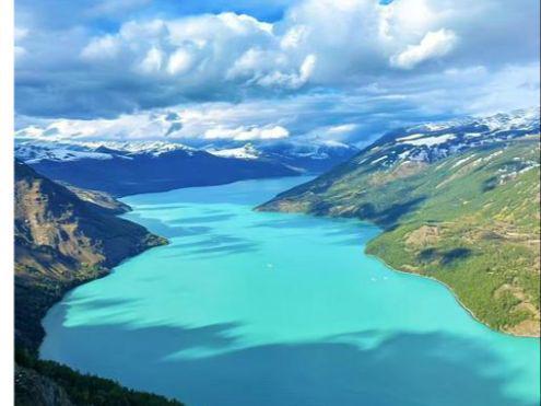
That is a fair but not punishing rhythm. Days 8 and 14 are intentional buffers; day 21 is the only genuinely long haul, and you can split it by overnighting in Kuqa or Aksu if flights from Hotan are tight. For the full backbone and alternatives, our Xinjiang travel guide has the region-by-region detail.
North: Altai and the Ili valley
The first week repeats the strongest hits of the shorter loops — Tianchi, the Urho yardangs, Kanas, Hemu, Koktokay — but with no need to rush. I give Kanas and Hemu two nights each here. The Altai in late September is the best scenery in the north: golden larch against dark conifers, low mist in the Hemu valley, empty trails once the day coaches leave.
Ili is the grassland heart. Sayram Lake at 2,071 metres is cold and windy; stay lakeside. Nalati and Bayinbulak are the two big pastures — Nalati the developed one with cable cars, Bayinbulak the high, open one at 2,500 metres with the Kaidu River bends and swans. Both are worth it on a three-week trip; on a shorter one I would drop one.
The Duku Highway: Tianshan in a day
Day 13 is the crossing. The Duku Highway runs 561 kilometres from Dushanzi to Kuqa over the Tianshan, hitting 3,400 metres at its high point. You start in green alpine meadow and end in red desert. It is open roughly June to early October only. Drive it with a local driver — narrow, cliff-edged, weather-fickle. Our Duku Highway road trip guide covers the pull-offs (Dalongpool, the Tianshan pass, the glacier viewpoint) and the seasonal rules.
South: Tarim towns and Kashgar
Below the Tianshan the character changes. Kuqa has the Kizil caves — the oldest Buddhist murals in Xinjiang, about an hour’s drive west — and a relaxed bazaar town. Aksu is a handy break. Kashgar is the climax of the south: the old city (Id Kah mosque, the maze of lane houses), the Sunday livestock market if your timing is right, and the gateway feel of the far west. Spend a full day there before the Pamir, partly to sort the permit and partly to acclimatise — Kashgar sits at 1,300 metres, a gentle step up from the plains.
The Pamir Plateau and Border Permit
This is where the 21-day trip earns its length. From Kashgar the G314 climbs to Tashkurgan at about 3,000 metres, running beside the Karakoram Highway past Karakul Lake (with Muztagh Ata’s snow cone behind it) to the Khunjerab Pass area at the Pakistan border, around 4,700 metres. The air is thin and the road is high; I tell clients to spend two nights in Tashkurgan rather than rush back.
Permit logistics: you need a Border Permit (边境管理区通行证) for Tashkurgan county. Get it in Kashgar at the entry-exit office with your passport — it takes a morning, it is free, and you cannot do it online or in advance from Urumqi. Foreign travellers should also confirm current rules, as the Pamir border road has periodic restrictions. Do not book the Pamir leg on days 18–19 unless the permit is in hand.
Hotan and the desert return
Hotan (Hetian) is the southern anchor — jade market, the old town, and a different dialect and feel from Kashgar. From Hotan the Tarim Desert Highway (G3012/Tarum) runs north through the Taklamakan, the world’s second-largest shifting-sand desert, to the northern rim and on to Turpan and Urumqi. It is a long, flat, hypnotic drive; split it if you want. Turpan, 150 metres below sea level, gives you the Flaming Mountains and Jiaohe ruins as a last contrast before the flight home.
Payment, SIM and everyday logistics
A three-week trip throws up the small hassles that a short one hides. Carry both cash (RMB 1,000–2,000 in small notes) and a Chinese payment app — Alipay and WeChat Pay cover almost all town spending, but remote scenic-area vendors and Pamir stalls often take cash only, and foreign cards are unreliable at the counter. Buy a local SIM at Urumqi airport (China Mobile or Unicom) with your passport; registration is quick and gives you maps and ride apps for the whole loop. Note that Google, WhatsApp and similar are blocked without a VPN, so download offline maps and sort messages before you lose access, or use a roaming eSIM that routes outside the firewall. Laundry is available in the big towns but not in Kanas, Hemu or Tashkurgan, so pack enough for four days between washes.
Buffer days and acclimatisation
Four buffer days are built in (8, 14, plus the flexible 20–21). Use them for weather, a sick day, or simply resting — a three-week trip with zero slack becomes a chore. On altitude: nothing on this route is extreme, but you cross 2,500 metres at Bayinbulak and 3,000+ on the Pamir. The design already helps — you sleep in Kashgar (1,300 m) before climbing, and you hold two nights at Tashkurgan rather than one. Drink water, go easy on alcohol the first night up high, and keep the first Pamir drive short.
Practical tips for a three-week trip
- Hire a driver for the whole loop. RMB 800–1,200 per day buys a car, fuel, and a local who handles checkpoints. Self-driving 4,500 km with permit desks is heavier than it looks.
- Book the scarce rooms early. Kanas, Hemu, Sayram, Bayinbulak and Tashkurgan have limited beds and sell out in peak season. Pay for in-area stays.
- Carry your passport daily. Checkpoints are routine on inter-city roads; keep it accessible.
- Pack for two climates. You will go from 30°C desert to near-freezing Pamir nights. Layers and a warm jacket.
- Confirm the Duku and Pamir status before you fly. Both are seasonal or periodically restricted; build the plan so a closure costs you a detour, not the trip.
For city-level logistics across the route, the Xinjiang cities guides break down each stop, and the Xinjiang attractions pages cover the specific sites worth your time.
Frequently asked questions
Is 21 days too long for Xinjiang?
No — it is the right length for a full north-plus-south loop. Two weeks forces hard cuts; three weeks lets you add Kashgar, the Pamir and Hotan without rushing the north. If you only have two weeks, drop the far west.
Do I need a Border Permit for the whole trip?
Only for Tashkurgan and the Pamir. Get it in Kashgar with your passport; it is free and takes a morning. The rest of the loop needs no special permit beyond a standard China visa.
How do I handle altitude on the Pamir?
Sleep in Kashgar (1,300 m) first, then hold two nights in Tashkurgan (3,000 m) instead of one. The Khunjerab area reaches 4,700 m, so keep that day’s drive short and hydrate. Most healthy travellers are fine with this build-up.
Can I do this by public transport?
Not the whole loop. Trains and buses reach the big towns (Urumqi, Yining, Kashgar, Turpan) but not Kanas, Hemu, Sayram, Bayinbulak, the Duku or the Pamir. A driver or small-group tour is the realistic option.
What is the best season for the full loop?
September. Kanas larches are gold, the Duku is open, the Pamir roads are clear, and the south is no longer baking. June–July has grassland flowers but peak crowds; avoid winter, when the Duku and Pamir passes close.
How much does a 21-day trip cost?
With a private driver and mid-range hotels, roughly RMB 15,000–25,000 per person, more if you insist on the scarce in-scenic-area rooms. Transport and rooms dominate; food and site entries are modest.