

Published: 2026-07-31 | Author: Karl Huang
The first time I drove into Alagou was 14 October 2017, in a rented Haval H6 with a cracked windscreen and 62,000 km on the clock. I had filled up at the Sinopec station on the east side of Toksun county town at 07:40, paid 312 RMB for a full tank, and eaten a plate of hand-pulled noodles for 25 RMB at a Uyghur place two doors down. By 09:15 I was 40 km up the valley and had passed no ticket gate, souvenir stall, or shuttle bus. That absence is the whole point of this Alagou Grand Canyon Guide: Alagou (阿拉沟) is not a packaged scenic area. It is a 100-kilometre working valley on the southern flank of the Tianshan, with a river, red conglomerate walls, coal trucks, a 2,500-year-old Saka cemetery, and the concrete skeletons of an abandoned Cold War industrial zone. Arrive expecting boardwalks and you will be disappointed by 11:00. Arrive expecting a long, rough, genuinely strange drive and you will remember it for years.
Quick Reference
| Item | Detail |
|---|---|
| Location | Alagou Township, Toksun County, Turpan Prefecture, Xinjiang; southern slope of the eastern Tianshan |
| Entrance fee | No ticket gate and no admission fee at the time of writing. Some individual sites inside the valley may be fenced or closed without notice. |
| Best time | Late May to early October; September is the strongest month |
| Elevation | About 1,100 m at the valley mouth, rising to 2,000–2,500 m upstream and higher on the passes toward Baluntai |
| Distance from Urumqi | 200–260 km depending on entry point; 3.5 to 5 hours driving |
| Role | Unticketed backroad canyon, archaeological site and Third Front industrial ruin in one valley |
| Time needed | One full day; two if you continue through to Bayinbuluke |
| Vehicle | Private car or chartered driver; no public bus runs the valley |
What Alagou Actually Looks Like
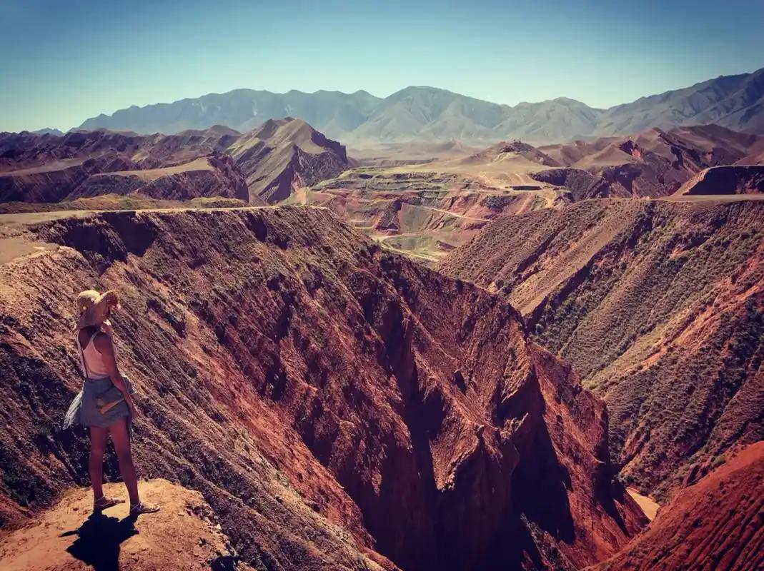
The name is usually explained as coming from a Mongolian root meaning piebald or multicoloured, and inside the gorge that makes sense. The rock is banded: rust-red conglomerate over grey shale, with seams of ochre and near-black, and in early light the striping is obvious to anyone. In the narrowest sections the walls stand 100 to 200 metres above the road and the gap at the bottom barely fits the river and the tarmac together.
The valley is not uniform, which is what makes a full day worthwhile. The lower 30 km near Yuergou are dry, stony, and industrial. Around the middle the gorge tightens and the colour intensifies. Higher up the walls fall back and the ground turns green: spruce on north-facing slopes, Kazakh summer camps on the flats, horses loose on the grass in July. At a herder’s yurt above the 70 km mark in June 2019 I was handed a bowl of milk tea I had not asked for, and paid nothing for it despite trying twice.
What surprised me most was the industrial archaeology. From the late 1960s the central government moved defence production inland under the Third Front programme, and factories went deep into this valley precisely because it was hard to find. What is left is a scatter of roofless workshops, apartment blocks with trees growing through the floors, and painted slogans still faintly legible on concrete. Thousands of people lived here. Most of it emptied out through the 1980s and 1990s as production relocated. That hour on foot is the reason any Alagou Grand Canyon Guide should send you further than the first viewpoint.
Then there is the deep history. The Alagou tomb group, excavated in the late 1970s, produced Saka-period burials generally dated to roughly the fifth to third centuries BC, with animal-style gold ornaments and textile fragments that included Chinese silk. Silk in a nomadic grave here is physical evidence of exchange across the Tianshan before the Han dynasty formally opened the Silk Road. The site is protected, largely unmarked, and there is little for a casual visitor to see. Go for the context, and do not dig, probe, or remove anything.
How to Get There
There are two ends to the valley and the route you pick changes the trip completely. Anyone using this Alagou Grand Canyon Guide as a driving plan should fix the direction before leaving town.
From Urumqi (most common). Take the G30 or G0711 expressway toward Toksun, roughly 130 km and 1.5 hours to the county town. Refuel there; it is the last reliable fuel and the last supermarket. Then head south-west on the provincial road toward Yuergou and turn up into the valley. Budget 4 to 5 hours from Urumqi to the middle of the gorge with stops. For a base with hotels and food, our Toksun travel guide covers the town in detail.
From Turpan. Turpan city to Toksun is 55 km on the expressway, half an hour. This works well if you are already doing Gaochang, the Flaming Mountains, and Grape Valley and want one day unlike the rest. See the Turpan travel guide for how to slot it in.
From the south, via Baluntai. The valley road continues over the Tianshan and drops into Hejing County, connecting toward Baluntai and the grasslands. Drivers use it as a shortcut between the Turpan Basin and the Bayinbuluke area. It is also the part most likely to be closed by snow, roadworks, or flood damage. Read the Bayinbuluke Grassland travel guide before committing, and confirm locally on the day that the through route is open. Do not rely on a mapping app; I have twice been routed onto a road that was physically barriered.
By train. The Southern Xinjiang railway passes through the lower valley and Yuergou has a small station, but services are limited and it drops you at the mouth of a 100 km valley with no onward transport. Treat rail as a curiosity rather than a plan.
Chartered car. A car with driver from Urumqi for a long day typically runs 800 to 1,200 RMB depending on vehicle and season; from Turpan or Toksun it is cheaper. Agree the full route in advance, in writing if possible, because some drivers will happily take you 20 km in and call that the canyon.
Best Time to Visit: What This Alagou Grand Canyon Guide Recommends
Ask ten drivers in Toksun about the best time to visit Alagou Grand Canyon and the answers spread across five months, because they are describing different parts of the valley.
Spring (April to May). The lower valley greens up early and the Turpan Basin below is already warm. The upper valley may still hold snow into May and meltwater can put water across the road. April is workable at the bottom, marginal at the top.
Summer (June to August). The grass is at its best and the herders are up at the summer camps. This is also flash-flood season. Rain that falls on bare slopes 20 km away arrives in the gorge as muddy water carrying gravel, and it can happen under a blue sky directly overhead. Do not camp on the riverbed, do not park in a dry side channel, and if the water turns brown while you watch it, drive out. Valley temperatures are far more tolerable than the 40°C-plus of Turpan city in July, which is one honest reason locals come up here.
Autumn (September to mid-October). My pick, and the season this Alagou Grand Canyon Guide is built around. The poplars turn, the air is clear, flood risk drops sharply, and the red rock photographs well in low light. Avoid the National Day holiday, 1 to 7 October, when even remote valleys fill with self-drive traffic.
Winter (November to March). The passes close, the upper road is unmaintained, and nothing is open at altitude. Not recommended without a proper 4WD, winter tyres, a companion vehicle, and a reason.
Short answer: go in the second half of September. If that is impossible, June is the next best, with flood awareness. That timing also lines up with the rest of a northern Xinjiang travel guide route, since the grasslands and the Duku Highway are still open then.
Where to Stay
Budget. Guesthouses and business hotels in Toksun county town, generally 100 to 180 RMB for a clean double with air conditioning, 20 minutes from the valley approach. Some small family guesthouses cannot register foreign passports, so confirm before you pay.
Mid-range. Turpan city, 3-star and 4-star properties around 250 to 450 RMB with breakfast and reliable foreigner registration. This is the sensible base for most international visitors, because it combines Alagou with the rest of the Turpan sights.
Upper range. Nothing upmarket exists near the canyon. For a genuinely comfortable hotel, stay in Urumqi at 500 to 900 RMB and accept a long day trip.
Inside the valley. Seasonal herder homestays and farmhouse rooms operate in summer, usually 80 to 150 RMB with dinner, arranged on the spot with no online booking. Availability is unpredictable and passport registration is generally not possible. Camping is fine in most of the valley, but choose high ground well away from the river and carry out everything you bring in.
Food
Toksun is genuinely famous within Xinjiang for one dish, and it is worth planning your day around lunch.
- Toksun laghman (托克逊拌面), hand-pulled noodles with a stir-fried topping, 22 to 35 RMB. Plain noodle refills are traditionally free in proper laghman houses; ask before assuming.
- Kawap (lamb skewers), 5 to 8 RMB each. Four with a plate of noodles is a full meal.
- Nan bread, 3 to 8 RMB by size. Buy two for the car; they keep for days.
- Big plate chicken (大盘鸡), 90 to 140 RMB for a portion that feeds three, with belt noodles added at the end.
- Samsa (baked lamb pastries), 6 to 10 RMB, best straight out of the tandoor.
- Milk tea from herders in summer, usually offered as hospitality rather than sold. Bring tea, sweets, or fruit from town to give back.
Past the township, food is close to nonexistent. Carry lunch and more water than you think you need. Prices reflect what I paid recently and will drift.
Practical Tips
- Carry your passport and expect checks. Toksun and the surrounding area have police checkpoints and registration procedures, and foreign passports are processed manually. Keep the original on you, not in the boot.
- Confirm access on the day. Sections of the valley have at times been restricted for mining, road repair, or safety. A route open last month may be shut today. Ask at your hotel, at the checkpoint, or at the last petrol station.
- Full tank, always. Fuel up in Toksun; there is none inside the valley. Stations here register the vehicle and may ask passengers to wait outside the forecourt. That is normal.
- Signal drops out. Expect long stretches with no coverage. Download offline maps and tell someone your route and expected return time.
- Watch for coal and ore trucks. Loaded trucks take the racing line on blind bends. Drive slowly, sound the horn on corners, and never stop on the carriageway for photos.
- Respect the archaeology. Do not climb tomb mounds, enter fenced areas, or pick up pottery fragments. Removing artefacts from a protected site is a criminal matter.
- Ruins are unstable. The factory blocks have rotten stairs, open shafts, exposed rebar, and no lighting. Look from ground level and do not enter alone.
- Flood discipline. Never camp or park in a dry channel. If rain starts upstream, get to high ground until the water clears.
- Take your rubbish out. There is no collection service, and the herders who use this valley in summer live with whatever visitors leave.
- Set expectations. Compared with a developed, ticketed site such as Tianshan Grand Canyon, Alagou has no facilities, no English signage, and no rescue infrastructure. That trade is the appeal, but it is a real trade.
Sample Itinerary
Day 1: Turpan or Toksun base, full day in the valley
- 07:00 Leave Turpan, or 07:40 from Toksun. Buy nan and water first.
- 08:15 Refuel in Toksun; last supermarket stop.
- 09:00 Enter the valley near Yuergou. Dry and industrial at first. Keep driving.
- 09:45 First serious narrows. Park on a wide shoulder and walk 15 minutes for the banded walls.
- 11:00 Old industrial area. Ninety minutes on foot outside the blocks is plenty.
- 12:45 Picnic lunch by the river, well above the water line.
- 14:00 Continue up as the gorge opens into spruce and herder camps. Best driving of the day.
- 16:00 Turnaround unless you are continuing south; beyond here the passes are a commitment.
- 18:30 Laghman back in Toksun. Turpan by 19:30, Urumqi by 21:00.
Day 2 (optional): through-route to the grasslands
- 08:00 Early start, having confirmed the pass is open.
- 10:30 Cross into Hejing County, descending toward Baluntai.
- 13:00 Lunch in Baluntai, then continue toward the Bayinbuluke area for sunset on the grassland.
The valley slots neatly into a Turpan-to-Bayingolin loop. More options sit in our Xinjiang attractions archive.
FAQ
Is there an entrance fee?
There was no ticket gate or admission charge on my visits. It is a public road through a working valley, not a managed scenic area. That could change if the site is developed, so verify locally.
Can foreign tourists visit Alagou?
Generally yes, and I have met foreign travellers in Toksun. Access rules in border and resource areas can change with little notice, and checkpoints have discretion. Carry your passport, allow extra time, and keep a fallback plan. A local driver removes most of the friction.
Do I need a 4WD?
Not for the main valley road in summer and autumn; a saloon with decent ground clearance handles it. For the high passes through to Hejing, or any shoulder-season attempt, take a higher-clearance vehicle.
How long should I allow?
A full day from Turpan or Toksun, roughly twelve hours door to door. Two days for the through-route. Half a day only gets you into the dullest section.
How does it compare with Kuqa Grand Canyon or Dushanzi?
Kuqa is more dramatic as pure rock scenery, and it is ticketed and developed. Dushanzi is deeper and easier to reach from the Duku Highway. Alagou wins on solitude and on the odd combination of Saka tombs and Cold War ruins in one valley. Want the visual payoff? Pick Kuqa. Want the drive and the history? Pick this one.
Disclaimer
Prices, road access, checkpoint procedures, and permit requirements in Xinjiang change frequently and often at short notice. Everything in this Alagou Grand Canyon Guide reflects my own visits and the situation as I understood it at the time of writing; none of it is a guarantee. Fees are approximate and in Chinese yuan. Access to specific sites, including archaeological areas and roads through mining zones, may be restricted without public announcement. Before travelling, confirm current conditions with your hotel, a licensed local operator, or the relevant official authority, and follow all posted regulations and the instructions of on-site personnel.